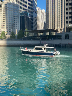
We left Chicago on Thursday 9/8 and headed down the river system. This section of the Loop is a collection of rivers, canals, and lakes that will take us from Chicago down to Mobile, Alabama. We hope to be in Mobile sometime in late November.
Ok – Ok – I know we have been quiet for a while but it’s all good. We’ve been a little busy lately. Moving down the rivers is a pretty time-consuming adventure – at least the way that Chrisy and Roger approach it. We research all the available anchorages, free walls, and marinas and see which ones fit into the schedule for the distance that we want to travel. The research consists of multiple cruising guides and a few on-line sources. While we’re underway we’re pretty dialed in to any hazards like shoaling or random logs that might be floating down the river. The bad news is that the river is down which means that shoaling is a bit more of a problem. The good news is that the river is down which means that there isn’t as much debris floating down the river.
And there’s the business of the barges. These things are absolutely massive. They’re several hundred feet in length and can be eighty feet wide. When you see one coming at you – you get the heck out of the way. Fortunately, we have a navigation system called AIS – Automated Identification System – which tells us the name, location, speed and direction of travel for all of the barges. Little icons appear on our chart-plotter that we click on to give us all the information we need. We then hail the tug captain on a special VHF channel and ask for instructions as to where he wants us. The tugs don’t use the traditional port and starboard. They use a system of 1’s and 2’s. If he says, “I want you on the 1,” that means turn to starboard and pass port-to-port for an oncoming tug or on his starboard side if we are overtaking him. Either way, a request for a pass on the 1 means a turn to starboard, which makes life very easy. The tug captains have been really nice, and they are always looking out for the cruisers. They obviously know the rivers incredibly well and always ask us to pass on the side that will be the safest for us.
The locks have also been a bit of a challenge. The Brandon Lock was closed for a while for maintenance. Then they opened early but then the Peoria Lock needed to test a bubbling system to ward off the carp. They decided to close 7 AM- 7PM M, Tu, Th, Fr – yikes – how do you squeeze through that? Day 1 of the Rivers we had hoped to get to the Joliet Wall – 35 miles no problem. Sadly, the Lockport Lock did not want to play fair and would not let a fleet of loopers down. We stayed on a crumbling wall that was an adventure to get Millie to shore. Day 2 we made it through Lockport and Brandon Locks after a 90-minute wait then the Dresden Lock and the Marseille Lock – long day, 4 locks and a bunch of miles. We were both pretty tired and Chrisy called a “Chrisy Day” at Heritage Harbor. Great call – they have a pool and a restaurant and we were able to take a breather after two pretty long days on the rivers.
Day 4 – remember that Day 3 was a Chrisy Day – Sunday 9/11 we went through two locks and covered 85 miles on a day that most of the loopers decided to stay put because it wasn’t the best weather. We wanted to get through the Peoria Lock on a Sunday because of the bubble testing restrictions. Day 5 Monday 9/12 - a few more locks and 63 miles– we’re really pushing now. Day 6 Tuesday 9/13 – 51 miles – no locks easy day. Day 7 Wednesday 9/14 – 32 miles and no locks another pretty easy day. After Day 7 we landed on Alton, Illinois just 20 miles north of St Louis. We’re done with the Illinois River and have started down the Mississippi – now that feels pretty good. It’s time for a break so we have a three-night stay in Alton so we can visit St. Louis.
That’s it for now – more posts to follow on a super fun day in St. Louis and the Mississippi.


